Life in Mycenaean Pylos
Σελίδα 2 από 4
Literacy in the Mycenaean world was confined to a rather small number of people. Just twenty-six scribes have been identified by their handwriting at Pylos (and another eighteen groups of tablets may each represent a separate scribal hand). So far, writing is not attested for any purpose other than economic administration. Despite the limitations of this written evidence, by considering what the tablets say, where they were found, and what was found with them we can retrieve a good deal of information about the activities a palace administration controlled.
The Pylos kingdom covered about 2,000 square km (775 square miles), and may have extended throughout modern Messenia (Fig. 37). It was divided for administrative purposes into two provinces, described on the tablets as "this side of Aigolaion" and "beyond Aigolaion." It seems obvious, particularly if you are standing at the palace, that the boundary between them is the mountain range clearly visible to the northeast (Fig. 18). This range, known to the later Greeks and Romans as Aigaleon, bisects the peninsula from northwest to southeast. The seven districts of the Pylian Hither Province and nine of the Further Province are listed in a fixed geographical order on several tablets, referring both to incoming taxes and to outgoing allocations from the palace.
One set of tax documents further reveals the relationships among the different districts. There is a tablet for each district, listing assessments and payments of six different commodities, as well as some exemptions. Not all the commodities have been identified: two are certainly a type of homespun cloth and oxhides, and honey and wax may be among the others. But they must be rather common and/or the quantities must be rather small, since all districts are required to contribute all six commodities. We have a basic understanding of how the tax system worked, though some details are still obscure. Palace administrators did not tax each district independently. Rather, they began by setting the provincial assessment, and within each province they grouped certain neighboring districts together so that the tax burden was allocated fairly among richer and poorer districts in each part of the kingdom. This proportional grouping has a wider significance as well. Allocations of pigs, wine, and hides by the palace to the districts show the same relative amounts for each fiscal group; this must be the basis of the whole economic administration of the kingdom.
This is not to say that the individual districts were beyond the direct interest of the palace. One tablet shows a

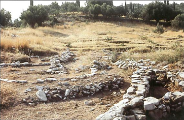
Figure 38. Nichoria, street in Area III
hierarchy of administrators for each, including a governor (koreter) and vice-governor (prokoreter). Individual districts are recorded as contributing flax, or housing bronzesmiths or textile workers employed by the palace. One district center has even been excavated, if scholars are right in identifying it with the site of Nichoria, across the Aigaleon range (Fig. 38). This settlement, on a hilltop near modern Rizomilo overlooking the Messenian Gulf, prospered and declined with the palace. Its geographic position and excavated remains match all the characteristics we expect of this town based on information in the tablets.26 As survey and excavation continue to fill in the map of settlements in the region, it is becoming possible to suggest other matchups between sites on the ground and important towns mentioned in the tablets.
Who ran this system, and what can we tell about the haves and the have-nots within it? The tablets are particularly valuable in confirming the existence of the wanax (king), for unlike Egypt and most Near Eastern cultures, Mycenaean Greece gives us no artistic images of a king, no ruler iconography at all. But from the texts we know that the wanax was the highest ranking member of a ranked society. This is particularly clear from a landholding document, where the royal plot is three times the size of that owned by the next ranking figure, the lawagetas (his name should mean that he leads the people, perhaps in a military sense). Other officials appear on other landholding tablets; they seem to receive the benefit of land in return for service of some kind, and they can rent out shares in turn to other individuals.