The Site

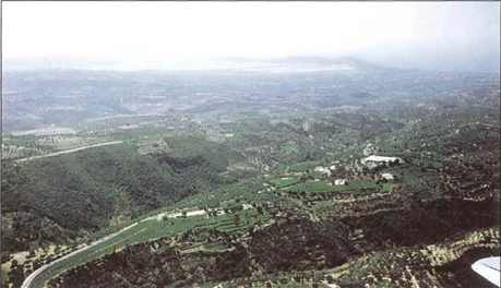
The hill of Epano Englianos is situated close beside and to the west of the highway some 4 km (2.4 miles) south of Chora and 17 km (10.2 miles) north of Pylos. The elevation (ca. 150 m, or 492 feet, above sea level), which has a maximum length of about 170 m (558 feet) from southwest to northeast and a width not exceeding 90 m (295 feet), rises abruptly on all sides in a steep, almost pre¬cipitous bank, some 4 to 7 m (13 to 23 feet) high. It is only toward the easternmost angle that a relatively narrow terrace descends somewhat lower, but even there access to the plateau could be gained only by a rough scramble up the bank until in 1952 the excavators cut an entrance way ascending through the steep slope.
The height had first been occupied by a settlement of the Middle Bronze Age,9 but before the palace was erected the summit of the hill was apparently cut down and leveled out. From this time on — about the beginning of the 13th century B.C. — this end of the hill seems to have been reserved for the administrative center and related buildings.
On the slopes and terraces below to the northwest, south¬west, and southeast Blegen excavated small parts of a lower town where the ordinary people lived. Investigations by the Pylos Regional Archaeological Project have since shown that the settlement also continued to the northeast; in fact, it was a substantial Mycenaean town that extended for hundreds of meters along the Englianos Ridge, and covered about 20 hectares (1 hectare = 10,000 square m, or 2.47 acres). Only a short distance to the northeast and south¬west of the acropolis are tholos ("beehive") tombs, the burial places of royalty and the elite, and, on a ridge descending toward the west, chamber tombs of ordinary people have been found.
The palace occupies only a little more than the south¬western half of the hill (Fig. 2), and the northeastern half seems to have been left open without large buildings, as at Tiryns. No contemporary fortification wall has been securely identified at Epano Englianos, although there was an Early Mycenaean circuit wall with a gateway at the northeast end of the site (see below, page 37).10 Several hundred meters west of the main palatial buildings, outside the fence that surrounds the site, subsurface geophysical prospection by the Pylos Regional Archaeological Project has located the foundations of a wall several meters thick that might also have defended the settlement at one stage in its history.